 |
Science Frontiers ONLINE No. 122: Mar-Apr 1999 |
|
|
The Mosier Mounds
In past issues (SF#38 and SF#115) we introduced the still-mysterious East Bay walls that stretch for some 50 miles along the foothills bordering San Francisco Bay. The strange, meandering stone lines of the Panamint Valley near Death Valley appeared in AR#3. In fact, the western states are festooned with curious stone structures. Now we add the Mosier Mounds to this file.
On the south bank of the Columbia, near Mosier, Oregon, archeologists have mapped a 30-acre complex of rock walls, cairns, pits, and troughs -- a vertiable maze of lithic structures. (See map.)
The most impressive features are alignments of stacked rocks that hug the contours of the slopes. Although their configuration suggests a battlement, the stone formations weave so sinuously that they cannot be defensive in nature. Some anthropologists suggest that these various lithic structures were used for burials, vision quests, and even the physical conditioning of the young men who were given the job of piling up all the stones!
No precise dates are available, but the Mosier Mounds probably predate European contact.
(Connolly, Thomas J., et al; "Mapping the Mosier Mounds: The Significance of Rock Feature Complexes on the Southern Columbia Plateau," Journal of Archaeo logical Science, 24:289, 1997.)
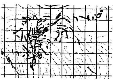 | Maps of the main concentrations of Mosier Mounds. The heavier lines represent the stacked rocks. The squares are 20-meters on a side. |